PAGASA Warns Tino May Become Super Typhoon, Visayas Now Under Signal 2
PAGASA: Severe Tropical Storm Tino may become a super typhoon. Visayas now under Signal 2. High risk of life-threatening storm surge.

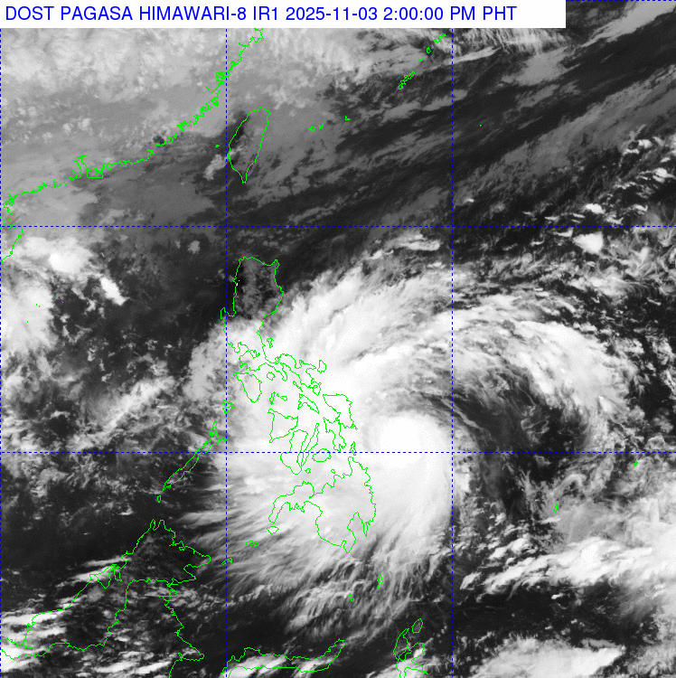
Residents across the Visayas are bracing for impact as Severe Tropical Storm Tino (international name: Kalmaegi) churns menacingly towards the Philippines. State meteorologists issued a stark warning on Monday, advising that the storm not only continues to strengthen but may reach the devastating 'super typhoon' category as it nears the archipelago.
The initial data provides a snapshot of the storm's power. As of 4 a.m. Monday, the Philippine Atmospheric, Geophysical and Astronomical Services Administration (Pagasa) located the centre of Tino approximately 430 kilometres east of Guiuan, Eastern Samar.
It was already packing maximum sustained winds of 110 kilometres per hour (kph) near the centre, with dangerous gusts reaching 135 kph, and was moving west-southwestward at approximately 25-30 kph.

The Frightening Potential Of Severe Tropical Storm Tino
The primary concern for forecasters is the storm's projected 'rapid intensification,' a scenario PAGASA weather specialist Daniel James Villamil described as 'highly likely.'
'Rapid intensification' is a process where a storm's maximum sustained winds increase by at least 55 kph in a 24-hour period. In its 5:00 a.m. update, PAGASA noted the storm is expected to achieve typhoon category status by the end of Monday.
The conditions are perfect for a dangerous escalation. 'The sea where Tino's center is going has a high sea surface temperature, so it is favorable for further intensification,' Villamil explained.
This explosive potential has led the state weather bureau to a grave conclusion: 'The possibility of reaching super typhoon category is not ruled out based on alternate scenarios and climatological data.'
Under PAGASA's classification, a 'super typhoon' is a cyclone with maximum sustained winds of 185 kph or more.
Beyond the wind, PAGASA has issued specific warnings for two other major hazards: storm surge and heavy rainfall.
- Storm Surge: There is a 'high risk of life-threatening and damaging storm surge' in low-lying coastal communities. Pagasa warned that surges could exceed 3 metres in parts of Eastern Samar and reach 2.1 to 3 metres in the Dinagat Islands and Leyte.
- Rainfall: 'Intense to torrential rains' (over 200 mm) are expected over Eastern Samar, Southern Leyte, Leyte, and the Dinagat Islands. 'Heavy to intense rains' (100-200 mm) are forecast for Surigao del Norte, Northern Samar, Sorsogon, Biliran, and other nearby provinces, bringing a severe threat of flash floods and landslides.

Severe Tropical Storm Tino: Charting The Destructive Path
PAGASA anticipates that Severe Tropical Storm Tino will make its initial landfall at or near its peak intensity. The expected target zone covers a wide area, including Eastern Samar, Leyte, or the Dinagat Islands, with landfall projected for Monday midnight or early Tuesday morning.
This path means the storm will then carve directly across the Visayas region before tracking over northern Palawan. It is expected to finally emerge over the West Philippine Sea by Wednesday morning or afternoon.
Even as the terrain attempts to weaken the cyclone, PAGASA warns the public to remain vigilant. 'While its interaction with the terrain will trigger a slight weakening, Tino is expected to remain as a typhoon throughout its passage over the country,' PAGASA stated.

Public Warnings Issued For Severe Tropical Storm Tino
In response to the immediate danger, PAGASA has already hoisted Tropical Cyclone Wind Signal (TCWS) No. 2 over several parts of the Visayas, indicating that damaging gale-force winds are expected within 24 hours. Residents in these areas are advised to secure property, prepare for possible evacuations, and avoid all sea travel, as conditions will become extremely hazardous.
The areas under TCWS No. 2 include:
- Central and southern portions of Eastern Samar
- Central and southern portions of Samar
- Leyte
- Biliran
- Southern Leyte
- Camotes Islands
- The eastern portion of Bohol.
A wider net of alerts is active under TCWS No.1, warning residents of strong winds expected within 36 hours. PAGASA has suspended maritime activities for smaller vessels in these areas and advised all residents to monitor updates closely.

Luzon:
- Sorsogon
- Masbate, including Ticao Island and Burias Island
- The southern portion of Albay
- The southern portion of Oriental Mindoro
- The southern portion of Occidental Mindoro
- Cuyo Islands
Visayas:
- Northern Samar
- The rest of Eastern Samar
- The rest of Samar
- The rest of Bohol
- The rest of Cebu, including the Bantayan Islands
- Siquijor
- Negros Oriental
- Negros Occidental
- Guimaras
- Iloilo
- Capiz
- Aklan
- Antique, including Caluya Islands

Mindanao:
- The central portion of Surigao del Sur
- The northern portion of Agusan del Sur
- The rest of Agusan del Norte
- The eastern portion of Misamis Oriental
- Camiguin
With Severe Tropical Storm Tino forecast to make landfall at or near its peak intensity, the danger of destructive winds, widespread flooding, and life-threatening storm surges is imminent. This is a critical time for all residents in signal-warned areas, especially those in the Visayas under TCWS No. 2.
Pay close attention to advisories from PAGASA and your local disaster management offices. Prioritise your family's safety and be prepared to evacuate immediately if authorities instruct you to do so.
© Copyright IBTimes 2025. All rights reserved.
- MOST POPULAR IN World