Super Typhoon Uwan Tracker: 'Monster Storm' Directly Hits the Philippines, Taiwan and Parts of China
Authorities urge millions across Luzon to prepare for life-threatening winds, flooding and landslides as the rapidly intensifying Super Typhoon Uwan nears landfall
The Philippines is once again on high alert as Super Typhoon Uwan — internationally known as Fung-Wong — surges across the Pacific Ocean, rapidly strengthening into a potentially catastrophic weather system. The massive storm, now classified as a Category 4 super typhoon, is forecast to make a direct hit on Luzon, the country's largest and most populated island, before possibly affecting Taiwan and parts of China in the coming days.
According to the latest advisory from the Philippine Atmospheric, Geophysical and Astronomical Services Administration (PAGASA), Uwan has undergone rapid intensification over the Philippine Sea during the past 24 hours. As of Saturday morning (8 November), the storm was located east of Samar, packing sustained winds of up to 220 km/h (138 mph) — enough to cause catastrophic damage should it make landfall at this strength.
A Rapidly Intensifying 'Monster Storm'
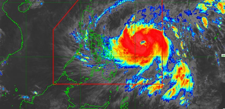
Satellite images show a vast and tightly formed cyclone growing in size and intensity as it approaches the Philippines. Meteorologists have described Uwan as one of the strongest and fastest-developing storms of 2025. The US Joint Typhoon Warning Center (JTWC) has confirmed that the system, previously designated Tropical Depression #32W, is moving west-northwest and is expected to hit peak intensity before striking land.
Forecast models from PAGASA, the Japan Meteorological Agency (JMA), and the JTWC all indicate that Uwan is likely to make landfall over Northern or Central Luzon on Monday, 10 November. The storm could bring destructive winds, torrential rainfall, widespread flooding and dangerous landslides.
The timing of Uwan's approach is particularly concerning as many regions in the Philippines are still recovering from Typhoon Tino (Kalmaegi), which struck only weeks ago. Officials have warned that Uwan could cause "equal or even greater" devastation, particularly in communities that have yet to rebuild.
Areas at Greatest Risk
PAGASA's tracking maps suggest that Uwan's eye may cut across Northern and Central Luzon, threatening provinces such as Cagayan, Isabela, Aurora, Nueva Ecija and Pangasinan. Even the capital region of Metro Manila may experience severe weather, including heavy rain, flash flooding and gale-force winds, depending on the storm's final trajectory.
Beyond the Philippines, the storm's outer rainbands could also impact Taiwan and the southeastern coast of China later in the week. Meteorologists note that if Uwan maintains its current intensity, it could continue to pose a serious threat even after crossing Luzon.
Residents Urged to Remain Vigilant
Authorities are urging residents to stay alert and take precautionary measures ahead of the expected landfall. Local governments across Luzon have begun mobilising emergency response teams, preparing evacuation centres, and coordinating with the National Disaster Risk Reduction and Management Council (NDRRMC) for possible large-scale evacuations.
'This is not a storm to underestimate,' a PAGASA spokesperson said during a televised update. 'We urge everyone in affected areas to prepare now and closely monitor official forecasts. Even small shifts in Uwan's path could mean significant differences in impact.'
Understanding the Typhoon's Strength
Meteorologists have explained that discrepancies between different wind speed reports — such as the one-minute average used by the JTWC and the ten-minute average used by PAGASA — should not be mistaken for inconsistency. Both measurement systems confirm that Uwan's strength comfortably falls within super typhoon classification, meaning winds are strong enough to cause extensive structural damage and power outages.
Key Details on Typhoon Uwan
- International name: Fung-Wong
- Local name: Uwan
- Category: Projected Category 4 Super Typhoon
- Peak winds: Up to 220 km/h (138 mph)
- Expected landfall: Monday, 10 November 2025
- Primary target area: Northern-Central Luzon, Philippines
- Secondary impact zones: Taiwan and southeastern China
Preparing for the Worst
With sea surface temperatures remaining high in the West Pacific, there is a risk that Uwan could continue to strengthen before making landfall. Authorities have advised residents to prepare emergency kits, secure loose objects, and follow evacuation orders as soon as they are issued.
While there remains some uncertainty in Uwan's precise track, meteorologists agree that it is a "monster storm" capable of inflicting severe damage across a wide area. As the typhoon edges closer, millions are bracing for what could be one of the most powerful and destructive storms of the year.
© Copyright IBTimes 2025. All rights reserved.
- MOST POPULAR IN World