Typhoon Uwan Threat: Signal No. 4 Raised Over Catanduanes, Northern Luzon Set for 'Catastrophic Destruction'
Typhoon Uwan is nearing Super Typhoon status; Signal No. 4 is raised. Surge warning for 3.0m waves across Luzon.

The Philippines is facing a terrifying escalation of its current weather threat, as Typhoon Uwan has rapidly intensified, forcing authorities to raise the danger level to Signal No. 4.
The state weather bureau, Philippine Atmospheric, Geophysical and Astronomical Services Administration (PAGASA), issued its most severe warning yet late Saturday night, confirming the typhoon is moving closer to the Bicol Region and is poised to make landfall within hours.
The forecast now includes the stark possibility of Uwan reaching Super Typhoon category before impact. This upgrade places areas in the central Philippines under an immediate and 'severe threat to life and property' from winds exceeding 118 km/h.
The entire country, still reeling from the effects of recent storms, is now bracing for a potentially catastrophic mix of typhoon-force winds, high seas up to 14.0 metres, and life-threatening storm surges exceeding 3.0 metres across multiple coastal areas, including Metro Manila.
The situation demands immediate public compliance with evacuation orders and disaster protocols.
Signal No. 4 Hoisted: The Escalating Threat from Typhoon Uwan
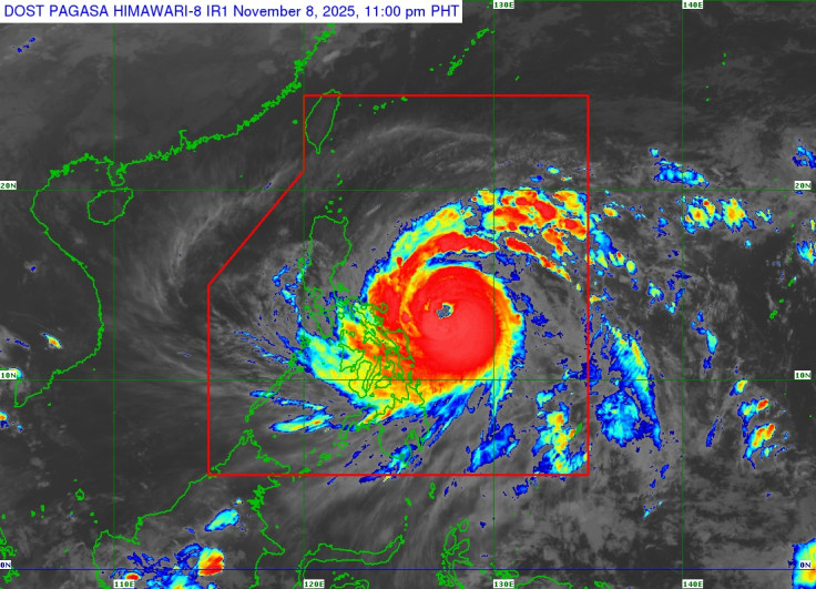
As of 10:00 pm on 8 November 2025, the centre of Typhoon Uwan (international name Fung-Wong) was estimated to be 380 km East of Virac, Catanduanes.
The storm has further intensified, now packing maximum sustained winds of 155 km/h near the centre, with gustiness of up to 190 km/h. The typhoon is moving west northwestward at 35 km/h, meaning the clock is ticking rapidly for residents in the projected path.
Strong to typhoon-force winds are extending outwards up to 800 km from the centre, ensuring widespread impacts.
The official wind signal classification has escalated, meaning that residents in these areas face different levels of immediate threat:
- TCWS No. 4 (Typhoon-Force Winds): Catanduanes is under the highest threat, with winds ranging from 118 to 184 km/h. This presents a 'Significant to severe threat to life and property'.
- TCWS No. 3 (Storm-Force Winds): This includes Aurora, the northern and eastern portions of Quezon (including Polillo Islands), Camarines Norte, Camarines Sur, Albay, the northern and eastern portions of Sorsogon, and the eastern portion of Northern Samar. Wind speeds range from 89 to 117 km/h, posing a 'Moderate to significant threat to life and property'.
- TCWS No. 2 (Gale-Force Winds): Winds of 62 to 88 km/h are expected across a vast area including Metro Manila, the rest of Quezon, Cavite, Batangas, Masbate, the rest of Northern Samar, and portions of Samar, Eastern Samar, and Biliran.
- TCWS No. 1 (Strong Winds): The alert for minimal to minor impacts extends as far as Batanes, Leyte, Bohol, and parts of Cebu, Negros, and Surigao.
Life-Threatening Storm Surge and Landfall Forecast for Typhoon Uwan
The immediate danger extends beyond wind speed to water-based hazards. PAGASA has issued an urgent Storm Surge Warning No. 5, detailing the high risk of life-threatening and damaging storm surges with peak heights exceeding 3.0 metres within the next 48 hours.
This severe storm surge threat covers low-lying or exposed coastal communities across numerous provinces, including the major metropolitan areas of Metro Manila, Cavite, Batangas, and Quezon.
A Gale Warning is also in effect over the northern, eastern, and southern seaboards of Luzon, the eastern and central seaboards of Visayas, and the eastern seaboard of Mindanao.
Up to very rough, high, or very high seas of up to 14.0 metres are specifically forecast for the northern and eastern seaboards of Catanduanes, Camarines Sur, and Polillo Islands. Sea travel is now deemed risky for all types or tonnage of vessels.
The latest forecast track indicates that the centre of Uwan may pass close to Catanduanes tomorrow morning and is expected to make landfall over Aurora tomorrow (09 November) evening or Monday early morning.
However, the track may still shift, and there is an increasing possibility of a slight southward shift which may result in a direct hit or landfall over Catanduanes.
PAGASA confirmed that 'UWAN is forecast to rapidly intensify and may reach super typhoon category tomorrow, although the potential for a much faster intensification is not ruled out due to favorable environment. It may also make landfall at or near its peak lifetime intensity.'
Although the interaction with the terrain will cause Uwan to weaken, it is expected to remain a typhoon throughout its passage over Northern Luzon.
Considering these developments, the public and disaster risk reduction and management offices concerned are advised to take all necessary measures to protect life and property.
Persons living in areas identified to be highly or very highly susceptible to these hazards are advised to follow evacuation and other instructions from local officials.
© Copyright IBTimes 2025. All rights reserved.
- MOST POPULAR IN World