Tropical Storm Basyang Intensifies Ahead Of Looming Eastern Mindanao Landfall
A storm's track is never just a line on a map; it's a measure of how quickly ordinary life can be knocked off balance.


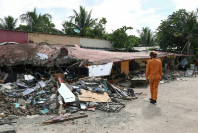
The first sign isn't always the wind. Sometimes it's the sea turning restless, as if it has picked an argument with the shoreline. Along parts of the Visayas and Mindanao, that shift is enough to send people into motion: boats dragged further up the beach, corrugated sheets checked for loose nails, phones charged even when the electricity is still behaving.
By late Thursday, Tropical Storm Basyang—international name Penha—was still offshore, but PAGASA's language had tightened in the way it tends to when the margins narrow. In its 5:00pm bulletin on 5 February, the Philippine weather agency said Basyang had 'slightly intensifies while approaching Eastern Mindanao,' with maximum sustained winds of 75 km/h near the centre and gusts reaching 90 km/h. The storm's central pressure was reported at 998 hPa, and its centre was estimated at 150 km east of Hinatuan, Surigao del Sur.
It was moving west-northwest at 25 km/h, which is fast enough to make a mockery of leisurely preparations, but not so fast that the waiting becomes brief. And the storm's reach—often the detail people skim past—was already wide: strong to gale-force winds extending as far as 380 km from the centre, according to PAGASA. That's the part that turns a 'local' storm into a regional headache.
Tropical Storm Basyang And The Map That Won't Sit Still
PAGASA's track and intensity outlook sketched an unsettling journey across some of the country's most storm-exposed corridors. On the current forecast track, the centre of Basyang was expected to make its initial landfall over Surigao del Sur 'tonight or tomorrow early morning', then cross Mindanao and emerge over the Bohol Sea on Friday morning.
From there, it may pass close to or make another landfall over Siquijor and the southern portion of Negros Oriental by Friday afternoon or evening, before emerging over the Sulu Sea by Friday evening or early Saturday. The forecast then has it traversing the northern portion of Palawan between Saturday afternoon and evening.
There's a particular cruelty in how often storms in the Philippines behave like this—touching down, slipping back over water, then reintroducing themselves somewhere else with a fresh set of problems. You hear it in the way forecasters hedge, and you see it in the way residents have learned not to treat a track line as a promise.
PAGASA emphasised that the track may still shift 'within the limit of the forecast confidence cone' and that heavy rainfall and severe winds can be experienced outside the expected landfall point. It's the sort of disclaimer people roll their eyes at until it becomes, suddenly, painfully relevant.
In terms of strength, the agency said Basyang may intensify further before its initial landfall, then slightly weaken as it interacts with land, while likely remaining a tropical storm. Further weakening into a tropical depression is forecast by Saturday, with a downgrade into a low pressure area by Sunday (8 February) afternoon or evening. In other words: even when the headline fades, the disruption often lingers.
Tropical Storm Basyang, Wind Signals, And The Real-World Disruption
Wind signals can sound like bureaucratic weather-speak, but they land in real life as cancelled ferries, shaky roofing, and schools or offices trying to guess whether 'business as usual' is bravery or stupidity.
PAGASA placed Tropical Cyclone Wind Signal (TCWS) No. 2—gale-force winds—over wide areas in the Visayas and Mindanao, including Siquijor; parts of Negros Oriental and Negros Occidental; the southern portion of Cebu; the southern portion of Bohol; and large sections of northern and eastern Mindanao including Surigao del Norte (including Siargao and the Bucas Grande Islands) and Surigao del Sur. TCWS No. 1—strong winds—covered additional areas across Luzon, the Visayas, and Mindanao, expanding the footprint of potential damage and everyday chaos.
At sea, the message was even less subtle. PAGASA said a Gale Warning was in effect over the eastern and central seaboards of the Visayas and the northern and eastern seaboards of Mindanao. Its 24-hour sea condition outlook warned of very rough seas—up to 5.5 metres along the seaboard of Surigao del Sur, and up to 5.0 metres for the seaboard of Surigao del Norte and around Siargao-Bucas Grande and Dinagat. The agency cautioned that sea travel is risky for all types of vessels and urged mariners to remain in port or seek shelter.
Then comes storm surge, the threat that can feel deceptively calm until it isn't. PAGASA warned of a minimal to moderate risk of storm surge, with peak heights reaching up to 2.0 metres within 48 hours in low-lying or exposed coastal communities across a wide spread of provinces—from parts of Mindoro, Romblon and Palawan to areas across the Visayas and Mindanao.
PAGASA's final advice was the kind that reads repetitive only to people who have never had to decide whether to leave home in the rain: disaster risk reduction offices and the public were urged to take 'all necessary measures' to protect life and property, with residents in highly susceptible areas told to follow evacuation and other instructions from local officials. It's not drama. It's what experience sounds like when it's trying to save you time.
© Copyright IBTimes 2025. All rights reserved.
- Recommended For You