Severe Thunderstorm Warning: Here's What Places in the US Should Be on Tornado Watch
Authorities warn damaging winds and possible tornadoes could continue as the storm system moves east across several states.
Severe thunderstorms and tornadoes have swept across the central United States on 10 March, leaving damaged homes, closed roads, and tens of thousands without power as the storm system continues moving east. Several counties issued emergency declarations.
As the storm shifted east overnight, authorities warned of continued risks including flash flooding and further tornado activity. Meteorologists said more than 55 million people remained under severe weather alerts stretching from Texas and Louisiana through to Pennsylvania.
Severe Thunderstorm Warning: Here's What Places In The US Should Be On Tornado Watch
Dangerous storms moved across the central United States from Tuesday night into Wednesday morning. The weather system produced tornadoes, large hail, and damaging winds across several states. More than 70,000 customers were left without power, with about one third of outages reported in Texas.
Storms stretched from Texas north through the Great Lakes region during the overnight hours. As the system shifts east on Wednesday, the primary risks include flash flooding and strong winds. Authorities continue to monitor the storm system as it affects large areas of the country.
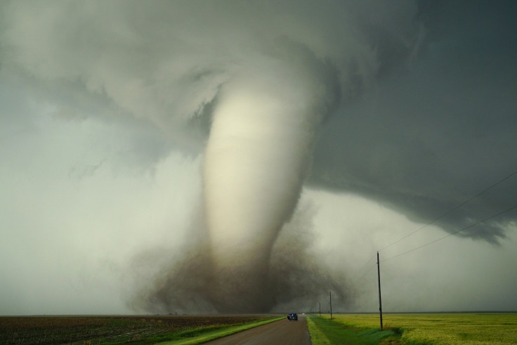
A tornado tracked through the Kankakee area of Illinois on the evening of 10 March 2026. In response, the Kankakee County Sheriff's Office activated its Emergency Operations Center and filed an emergency declaration with the state of Illinois. Officials reported no immediate deaths or missing people after the tornado passed through the area.
Tornado Hits Kankakee, Illinois
Kankakee Mayor Christopher W. Curtis confirmed that seven people sustained minor injuries during the storm. Several homes and commercial buildings were damaged in the area. Multiple roads remain closed due to fallen trees and downed power lines.
Drone footage showed emergency crews moving through neighbourhoods during the night. Crews walked through debris and fallen lumber while inspecting damaged houses. The footage showed search teams using flashlights while examining structures affected by the storm.
Earlier the same evening, the storm system produced another tornado near Pontiac, Illinois. The supercell thunderstorm continued travelling east for more than two hours across central Illinois and northern Indiana. During this period, the storm triggered the highest level of tornado warning, known as a Tornado Emergency, in Knox, Indiana.
Giant Hail And Severe Weather Across Several States
The same storm produced extremely large hail during its path across Illinois. Hail measuring more than five inches in diameter fell just south of Kankakee. Meteorologists said this measurement could set a new state record for Illinois.
Other regions reported significant hail and strong storms as the system moved across the country. Chicago recorded hail roughly the size of half-dollar coins during thunderstorms. In the Kansas City metropolitan area, hail measuring up to 3.5 inches in diameter was reported.
Severe weather also struck parts of Texas. A tornado was observed near Dudley, Texas during the storm activity. Baseball-sized hail was reported in Buffalo Gap, Texas during the same period of severe weather.
Flash Flooding And Storm Damage In Texas
Thunderstorms brought heavy rainfall to the Dallas–Fort Worth area late on Tuesday evening. The region remained under a flash flood warning for several hours as storms stalled over the metro area. Flooding risks continued into the early hours of Wednesday morning.
At the same time, thousands of electricity customers across the central United States lost power. More than 70,000 customers were affected during the height of the storm system. About one third of those outages occurred in Texas alone.
Local officials urged residents in affected areas to remain cautious while crews assessed damage. Kankakee County Sheriff Mike Downey said, 'I want to remind area residents to check on their neighbours and loved ones but to avoid unnecessary travel, if at all possible.' Emergency services remained active across several damaged neighbourhoods.
Areas Still Facing Tornado And Storm Risks
Weather officials said the storm threat will continue into Wednesday. Powerful storms may persist during the morning across the Lower Mississippi Valley and the Ohio Valley. Forecasters also warned that a renewed threat could develop later in the afternoon.
More than 55 million people remain under a Level 2 out of 5 risk for severe thunderstorms on Wednesday. The risk area stretches from Texas and Louisiana through several states and reaches as far as Pennsylvania. Damaging winds remain the main threat associated with the storms.
Forecasters also warned that a few tornadoes remain possible. The greatest risk areas include the Lower Mississippi Valley and parts of Ohio, Pennsylvania, and West Virginia. Current forecasts indicate that widespread severe thunderstorms are not expected on Thursday.
© Copyright IBTimes 2025. All rights reserved.
- Recommended For You