Tropical Cyclone Narelle Red Sky Explained: What Turned West Australia Bloody Red Right Before The Storm?
Dust and sunlight create stunning red skies ahead of Cyclone Narelle
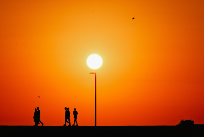
Residents across Western Australia reported deep red and orange skies ahead of Tropical Cyclone Narelle, with images widely shared online as the system approached the coast in late March. The phenomenon was observed in areas including Shark Bay on 27 March, shortly before the arrival of stronger winds and rainfall.
According to FOX Weather, the dust altered how sunlight travelled through the atmosphere, filtering out shorter wavelengths and allowing red tones to dominate. Meteorologists said the colour change was caused by iron-rich dust lifted into the atmosphere by the cyclone's outer winds.
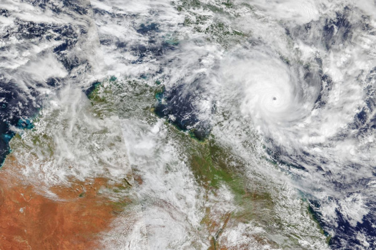
The event occurred as Narelle moved along a complex path across northern Australia. Data from NASA Earth Observatory shows the system made multiple landfalls between 20 and 23 March, bringing heavy rainfall, strong winds and flooding before tracking towards Western Australia.
How Dust and Sunlight Changed the Sky's Colour
The red sky was linked to dust carried from inland regions, particularly areas with high concentrations of iron oxide in the soil. Strong winds associated with the cyclone lifted fine particles into the atmosphere, forming a dense haze.
This dust layer changed how sunlight scattered. Shorter wavelengths such as blue light were dispersed, while longer wavelengths like red and orange passed through more easily, altering the sky's colour.
NO, that's not a filter! ☁️🔴 The sky turned an eerie shade of red in Western Australia as dust filled the air ahead of Tropical Cyclone Narelle. pic.twitter.com/dCQ2hjFluI
— AccuWeather (@accuweather) March 28, 2026
The effect was intensified during late afternoon and sunset, when sunlight travels through a thicker portion of the atmosphere, making the red tones appear deeper and more widespread.
Cyclone Path Increased Dust Transport
Tropical Cyclone Narelle followed an extended path across northern Australia before moving towards Western Australia. It intensified over warm waters in the Coral Sea before making landfall in Queensland and later crossing the Northern Territory.
During this period, the system brought more than 100 mm of rainfall to some areas and caused flooding in already saturated regions. As it travelled across dry inland terrain, it also picked up dust, which was later carried towards coastal areas.
🚨🇦🇺 Meanwhile in Australia
— Concerned Citizen (@BGatesIsaPyscho) March 27, 2026
Truly apocalyptic scenes from Australia, as skies turn a bright shade of red.
The phenomenon is being blamed on a Cyclone transporting dust across Western Australia. pic.twitter.com/YlhFbyWSia
Australia's Bureau of Meteorology said the system weakened into a tropical low before re-intensifying offshore, with forecasts indicating it could return towards the Western Australian coast later in the week.
Authorities Say Colour Does Not Signal Extra Risk
According to the Bureau of Meteorology, the unusual sky colour does not indicate additional danger beyond the cyclone itself. However, airborne dust can reduce visibility and affect air quality in some areas.
The primary risks were linked to the storm's intensity, including damaging winds, heavy rainfall and potential flooding, particularly along the Kimberley coast and further south as the system tracked along Western Australia.
Authorities advised residents to monitor official warnings, as conditions could change quickly, especially with the possibility of the system strengthening again offshore.
Focus Remains on Cyclone's Ongoing Impact
While the red skies drew widespread attention, meteorologists said the phenomenon reflects a known interaction between airborne dust and sunlight. According to the Bureau of Meteorology, the system is expected to continue moving along the Western Australian coast, with the potential to strengthen offshore before tracking further south.
Officials have advised residents to monitor updates and follow emergency guidance as conditions develop. While the red sky signalled the presence of strong winds capable of lifting dust, authorities emphasised that the primary concern remains the cyclone's direct impacts on communities in its path.
© Copyright IBTimes 2025. All rights reserved.
- Recommended For You