Tornado Warning In Wisconsin Issued As 'Strong Tornadoes' And Flooding Hit Region

Residents are urged to take shelter as a tornado warning is raised across parts of Wisconsin.
A tornado warning is in effect for parts of southeastern Wisconsin as 'strong tornadoes' and heavy rains threaten the region. The National Weather Service says one or more severe thunderstorms capable of producing tornadoes are moving into the area, with the potential for deadly winds and flash flooding.
The tornado watch covers southern Milwaukee County, southeastern Waukesha County, and most of Racine County through shortly after 2:00am CDT. At 1:32am CDT, the National Weather Service reported that a severe thunderstorm capable of producing a tornado was located over Potter Lake, or near East Troy, moving east at 72km/h (45 mph).
NWS Warns Tornado Could Strike Without Warning
The warning describes a 'radar‑indicated' tornado that could strike at any moment, bringing with it life‑threatening, flying debris. The NWS warns of potential damage to windows and roofs, also possible destruction to vehicles and mobile homes along the projected paths.
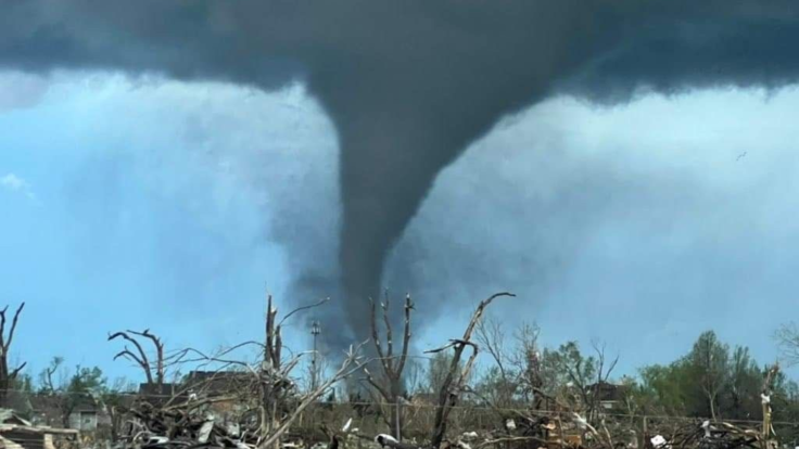
Footage from earlier tornado in Gilman, Wisconsin 🌪️
— ChaseWithHam (@Ham_BklynWx) April 14, 2026
How does it feel seeing your first tornado?
Chad Ducommun in Gilman, Wisconsin: “Yes it is the first tornado I saw… I wasn’t even expecting it the sun was shining. It was a very exciting moment. Lol”#wiwx #Wisconsin… pic.twitter.com/eVcTNUqLBb
A tornado was caught on video as it built and touched down on a field in Gilman, Wisconsin. The tornado came out of nowhere, according to a resident who saw it forming. 'Yes it is the first tornado I saw... I wasn't even expecting it the sun was shining. It was a very exciting moment. Lol,' he said.
Tornado Warning in Place Across Southeast Wisconsin
Communities in the path include Muskego, Wind Lake, Rochester, Big Bend, Browns Lake, Waterford North, Franklin, Eagle Lake, Union Grove, Raymond, Yorkville, Oak Creek, Sturtevant, Racine, and Mount Pleasant. People are urged to take cover as storms are forecast to build near those areas within 20 minutes.
Residents are instructed to move to a basement or an interior room on the lowest floor of a sturdy building, and to avoid windows. Those caught by the warning while outdoors, in mobile homes, or inside vehicles, should move to the closest shelter with substantial protection from flying debris.
A severe line of storms is also working its way through the region, with wind gusts of up to 104km/h (65mph). Because the ground is already saturated from prior melting snow and recent rains, a Flood Watch is also in effect through Tuesday morning, raising the risk of flash‑flood warnings.
Tornado Watch Raised Across Northeast Wisconsin
Severe thunderstorms are also being monitored in parts of Northeast Wisconsin, which saw flash floods from as much as 3 inches of torrential rain on Monday evening. Per Fox 11 News, all types of severe weather are possible, including large hail, tornadoes, and damaging straight-line winds. Residents are at the highest risk until early Tuesday morning.
A Tornado Watch was also raised for Waupaca, Outagamie, Waushara, Winnebago, Calumet, Green Lake, Fond du Lac and Sheboygan counties until late Monday evening. Scattered thunderstorms are expected in the region from Tuesday afternoon to evening. These could be severe, bringing large hail and damaging winds.
The alerts coincide with Severe Weather Awareness Week in Wisconsin. 'Severe weather, especially tornadoes, can develop quickly and with little to no warning,' said Greg Engle, Wisconsin Emergency Management Administrator. 'This week is an opportunity for families, schools and workplaces to take steps to be prepared for and know what to do when severe weather strikes.'
Wisconsin experiences an average of 23 tornadoes annually, according to WSAW-TV. 39 tornadoes were confirmed in 2025, 15 of which touched down on May 15 that year across southern Wisconsin.
© Copyright IBTimes 2025. All rights reserved.
- Recommended For You