Where Is Typhoon Uwan Now? Luzon Update Shows Monster Storm Ripping Through Northern Provinces
Typhoon Uwan weakens over Luzon, changes course; severe danger persists.
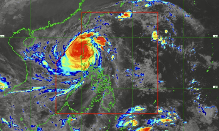
Residents across Luzon are tracking a storm of conflicting signals. Typhoon Uwan (Fung-Wong) has officially weakened, yet its path remains dangerously unpredictable, leaving millions on high alert. As of the latest 2:00 AM bulletin, the storm's eye is now over land, but its full impact is far from over.
Where Is Uwan Now, And Has It Truly Weakened?
In its 2:00 AM update on 10 November, DOST-PAGASA confirmed Typhoon Uwan has 'weakened into a Typhoon'. The storm's centre was last estimated over Bagulin, La Union, at 1:00 AM.
Despite this classification change, it remains incredibly powerful. The storm is packing maximum sustained winds of 165 km/h near the centre and destructive gustiness of up to 275 km/h, with a central pressure of 945 hPa.
Why The Storm's New Path Towards Taiwan Has Forecasters Worried
The typhoon is currently moving northwest at 30 km/h and is expected to emerge over the coastal waters of La Union this morning. Forecasters predict Uwan will maintain its strength over the West Philippine Sea until 11 November. After this, 'marginally favourable environmental conditions' are expected to cause it to gradually weaken.
The track shows a significant turn northeastward towards the Taiwan Strait by Wednesday, 12 November, while continuing to weaken. A potential landfall over western Taiwan is forecast for Thursday, 13 November, after which the storm is expected to rapidly deteriorate into a remnant low.
Millions Under Threat As Wind Signals Blanket Luzon
The typhoon's wind field is massive, with strong to typhoon-force winds extending 780 kilometres from the centre. This vast reach has placed millions under various Tropical Cyclone Wind Signals (TCWS).
TCWS No. 4, warning of 'significant to severe threat' from typhoon-force winds, is active across a huge swathe of Luzon. This includes La Union, Pangasinan, Benguet, Ifugao, Nueva Vizcaya, Mountain Province, and Aurora.
Meanwhile, TCWS No. 3 (storm-force winds) is in effect for parts of Metro Manila, Tarlac, Bataan, and the southern portions of Ilocos Norte. Lower signals remain hoisted for the rest of Luzon and parts of the Visayas, with specifics available from the state weather bureau.
Beyond The Wind: Life-Threatening Storm Surges And 'Very High' Seas
Authorities are urging the public 'not to focus on the center track'. Heavy rainfall, severe winds, and storm surge may still be experienced far from the landfall point.
A high risk of life-threatening coastal flooding, with storm surges possibly exceeding 3.0 metres, looms over the low-lying coastal communities of the Ilocos Region, Cagayan Valley, Central Luzon, and Metro Manila.
Furthermore, the 24-hour sea outlook is dire, warning of 'very rough, high, or very high seas' up to 14.0 metres. Sea travel is risky for all vessels, and mariners are advised to seek shelter immediately.
© Copyright IBTimes 2025. All rights reserved.
- MOST POPULAR IN World