Plains Tornado Warning: Multi-Day Storm Blasts Midwest With 'Softball-Sized' Hail and Long-Track Twisters
Forecasters issue a rare Level 4 warning as violent supercell thunderstorms threaten to trigger catastrophic destruction and widespread flash flooding.

A violent multi-day storm system is sweeping across the central United States, generating destructive tornadoes and giant hailstones that have forced millions to seek shelter.
The National Weather Service alerts have placed major population hubs across Nebraska, South Dakota, Iowa, and Minnesota on the highest level of weather readiness.
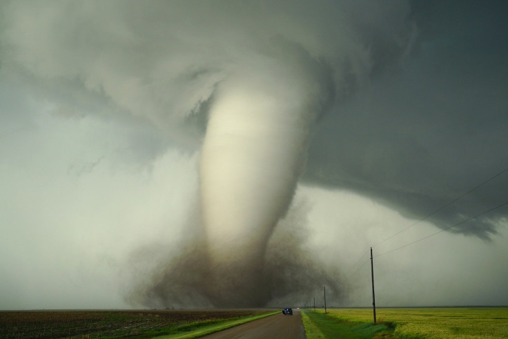
Meteorologists tracking the system warn that atmospheric conditions are ideal for producing long-track tornadoes, which US communities rarely witness outside of historic, high-end outbreaks. Intense supercell thunderstorms have already caused widespread damage, flattening agricultural structures, overturning heavy holiday campers, and knocking out local electricity grids.
Emergency response teams are urging families to monitor local digital radar channels instantly to protect lives and property from these rapidly moving vertical hazards.
Sunday's severe weather had been flagged days in advance by meteorologists watching a volatile mix of heat, humidity and high-altitude winds building over the central United States. By late afternoon, that atmospheric cocktail had produced classic rotating supercells across the Plains and Upper Midwest, triggering a cascade of tornado and severe thunderstorm warnings from Nebraska and Kansas through South Dakota and into Iowa and Minnesota.
🇺🇸 Tornado outbreak tore across central and eastern Nebraska, destroying multiple houses & downing power grids
— Lord Bebo (@MyLordBebo) May 18, 2026
A high-priority tornado emergency was declared further south near Hebron.
At least one rural home was completely obliterated by the intense rotation. But, seems like,… pic.twitter.com/DOZsMPKqTz
Reports through the evening painted a messy, familiar picture of spring on the Plains. In Nebraska, storm trackers filmed a large tornado carving across central parts of the state as sirens sounded in nearby communities. Buildings were damaged, campers were overturned, and trees and power lines were toppled, while damaging gusts knocked out electricity to thousands near the South Dakota–Nebraska border.
The hail was almost as alarming as the wind. Near Palmer, Nebraska, residents reported hailstones measuring 3.5 inches across, roughly the size of a softball. Other towns, including Dannebrog and Ashton, saw chunks of ice up to 3 inches wide striking vehicles, roofs and windows. Meteorologists attributed the giant hail to intense rotating thunderstorms in an extremely unstable atmosphere.
Plains Tornado Warnings Escalate From Omaha To Hebron
The evening escalated quickly along the Interstate corridors. In Iowa, a traffic camera along I‑29 near Salix captured a tornado crossing in front of passing vehicles under a tornado‑warned storm, a stark reminder of how quickly conditions on the road can flip from ordinary to life-threatening.
Farther south and west, the Omaha metro area found itself under a succession of alarms. The National Weather Service (NWS) first issued a Tornado Warning for parts of the city as a dangerous thunderstorm raced northeast at around 55 mph on Sunday night. Forecasters said the storm, located over La Vista near Ralston at about 8.14pm CT, had already produced tornadoes earlier in the evening near the Platte River northeast of Ashland.
Residents in southeastern Omaha, Bellevue, Council Bluffs, Carter Lake and surrounding suburbs were urged to get to the lowest floor of sturdy buildings and stay away from windows, amid warnings of a possible tornado, quarter‑sized hail and damaging winds.
Shortly afterwards, officials confirmed a tornado near Gretna, moving northeast at about 30 mph. That Tornado Warning covered parts of western Omaha, with the NWS cautioning that the storm could send dangerous flying debris into communities such as southwest Omaha, Millard, La Vista and Chalco.
It was Hebron, Nebraska, however, that underlined the seriousness of the evening. As storm tracker Brandon Copic followed a dangerous tornado in the area, the NWS escalated its alert to a Tornado Emergency, the most severe level of tornado warning available in the United States. Such emergencies are rare, reserved for moments when a large, destructive tornado is confirmed and heading directly towards populated areas.
Officials warned residents in Hebron to take cover immediately, move to the lowest storey and stay well clear of windows, citing the risk of severe structural damage and flying debris. A Tornado Emergency, meteorologists stressed, signals a potentially catastrophic event, rather than a routine severe weather scare.
Monday's Plains Tornado Threat Seen As Even More Volatile
As Sunday's storms were still pushing east into western Iowa and southern Minnesota, where a brief tornado was spotted north of Fairmont, attention among forecasters was already shifting uneasily to Monday.
The US Storm Prediction Centre issued a Level 4 out of 5 risk for parts of Kansas and Nebraska, a rare designation that implies a strong chance of significant severe weather. According to the FOX Forecast Centre, all the major ingredients for a high-end outbreak are expected to align over Kansas, Nebraska, Iowa and Missouri.
Meteorologists pointed to extremely warm, humid air pushing northward to fuel thunderstorms, combined with powerful upper-level winds that create the kind of vertical wind shear that helps storms rotate and spawn tornadoes. A strong upper-level storm system moving out of the Southwest is expected to interact with a cold front and a dryline on Monday afternoon, prompting rapid thunderstorm development.
The concern is that discrete supercells will form first, with conditions 'favourable for intense supercells capable of producing strong, long-track tornadoes and giant hail.' Later in the evening, those storms could merge into a larger line, increasing the risk of widespread damaging winds across the central Plains.
A storm chaser captured the incredible moment a massive tornado formed directly in front of him in central Nebraska on Sunday. https://t.co/4eTC1qSbJ7 pic.twitter.com/n6ppztRGhn
— ABC News (@ABC) May 18, 2026
Alongside the tornado and hail threat, hydrologists are also watching rainfall totals. The Weather Prediction Centre warned that 'training' storms, thunderstorms repeatedly moving over the same locations, could bring rain rates of 1 to 2 inches an hour, with isolated pockets seeing 2 to 4 inches overnight. Southeastern Nebraska and the Iowa–Missouri border region, where soils are already saturated, are of particular concern for flash flooding on roads, creeks and drainage channels.
On the ground, FOX Weather storm trackers such as Corey Gerken, battered by intense hail near Ohiowa, Nebraska, have been offering a close-up view of what those broad atmospheric charts mean in real time: dented vehicles, shredded foliage and skies that turn from late-spring blue to ominous green in minutes.
As the atmosphere reloads over the Plains, millions are being advised to keep a close eye on warnings and treat any mention of a Plains tornado threat as something more than just background noise.
© Copyright IBTimes 2025. All rights reserved.
- Recommended For You