

Super Typhoon Uwan Weakens, Now Passing Over La Union as 15 More Areas Marked High Risk
The centre of Typhoon Uwan now reported over La Union as it moves northwest
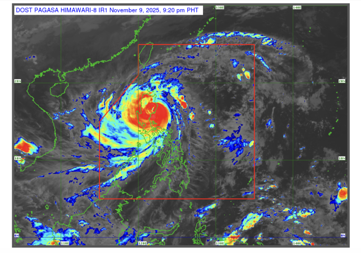
Super typhoon Fung-wong, known locally in the Philippines as Uwan, is said to have decreased in intensity as it crosses through Luzon. State meteorologists have also shared that the tropical cyclone is moving up to the northern regions, with 15 more areas marked high risk at tropical cyclone signal number four.
In a weather bulletin published by the Philippine Atmospheric, Geographical, and Astronomical Services Administration (PAGASA) at 4:00 AM local time on 10 November 2025, Typhoon Uwan is moving north as it made its landfall in Luzon over the weekend. The agency shared that as of 5:00 AM local time, the centre of Typhoon Uwan was estimated to be at the coastal waters of Bangar, La Union, in northwestern Luzon. PAGASA also shared that the typhoon is currently moving west-northwestward at a speed of 25 kilometres per hour.
Typhoon Uwan was initially referred to as a Super Typhoon; it has since weakened into a lesser typhoon status. PAGASA, however, warned that the strong winds brought about by the storm will continue to persist as it moves northwest over the next 12 hours before moving northward. The agency also predicted that the storm may intensify again on 12 November before moving northeast, in the direction of the Taiwan Strait.
PAGASA has predicted that Uwan will make landfall on western Taiwan by Thursday, 13 November. From there, the storm will continue to weaken until it reaches the waters near the Ryukyu Islands of Japan before turning into a remnant low.
TROPICAL CYCLONE BULLETIN NR. 16
— PAGASA-DOST (@dost_pagasa) November 9, 2025
Typhoon #UwanPH (FUNG-WONG)
Issued at 5:00 AM, 10 November 2025
Valid for broadcast until the next bulletin at 8:00 AM today.
“UWAN” WEAKENS FURTHER AND IS NOW OVER THE COASTAL WATERS OF LA UNION.
Link: https://t.co/Mb1nZQSD3s pic.twitter.com/0mfmNunQW0
15 More Areas Marked at Signal No. 4
Following the latest bulletins, PAGASA has issued a tropical cyclone warning signal number 4 to 15 more areas in Luzon. This comes after several regions were previously marked as signal number five. These areas include:
- The southwestern regions of Isabela
- Quirino
- Nueva Vizcaya
- The southern region of Kalinga
- Mountain Province
- The southern region of Abra
- Ifugao
- Benguet
- The central and southern regions of Ilocos Sur
- La Union
- Pangasinan
- Aurora
- Nueva Ecija
- The northern and eastern regions of Tarlac
- The northern region of Zambales
PAGASA has also issued new storm surge warnings to coastal communities in: Ilocos Region, Cagayan Valley, Central Luzon, Metro Manila, CALABARZON region, most of the MIMAROPA region, Camarines Norte, Camarines Sur, Catanduanes, and Masbate; Burias Island, Aklan, Antique, Guimaras, Negros Occidental, and Negros Oriental, which may be impacted by storm surges that can go up to three metres or higher.
Uwan previously made landfall over Dinalungan, Aurora on Sunday, 9 November, 2025 at 9:10 PM local time. Millions of people in places where the storm is seen as a potential risk to life and property were already forced to evacuate ahead of time. The government has also suspended classes for all educational levels as another measure. Airports in the Bicol region were also forced to suspend operations when the storm made landfall.
Residents in high-risk areas are urged to either evacuate as well as to stay prepared.
The arrival of Uwan came days after the destruction caused by Typhoon Kalmaegi in the Visayas region. The storm displaced thousands and left around 200 people dead before it moved into Vietnam.
© Copyright IBTimes 2025. All rights reserved.
- MOST POPULAR IN World


