Wilma's Terrifying Trajectory: Storm Threatens Millions In Visayas, Mindanao
Tropical Cyclone Wilma is forecast to slam Eastern Visayas and Caraga this weekend. PAGASA warns of a high probability of landfall.

The quiet calm of a midweek morning in the Philippines is often deceptive. Today, Wednesday, December 3, that familiar stillness is overshadowed by a chilling, yet predictable, threat brewing over the vast Pacific: the impending arrival of a new weather disturbance.
For the millions living in the eastern reaches of the archipelago, this is not just another weather update; it is a signal to prepare for the inevitable fury of the tropics.
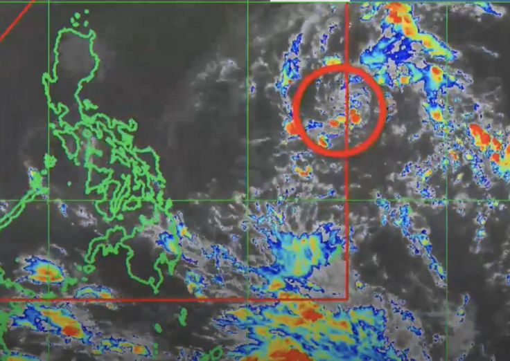
The Philippine Atmospheric, Geophysical and Astronomical Services Administration (PAGASA) is currently tracking a low-pressure area (LPA) poised to transform into a tropical cyclone. Once this system officially enters the Philippine Area of Responsibility (PAR) today, it will be christened Tropical Cyclone Wilma, placing it immediately on the nation's emergency radar.
In a recent update, PAGASA weather specialist Loriedin De la Cruz-Galicia confirmed the precise location of the disturbance. She said the LPA is still outside PAR but is expected to enter our area of responsibility today. There remains a high chance that it will develop into a tropical cyclone within the next 24 hours.
This projection means that local government units and disaster risk reduction management councils—particularly those in the potentially-affected regions—have only a very narrow window to enact preparedness protocols. Evacuation routes must be mapped, emergency food supplies secured, and critical infrastructure protected, all within the next two days.
The Terrifying Trajectory of Tropical Cyclone Wilma
The most concerning element of the initial meteorological data is the high probability of landfall. According to PAGASA's analysis, Tropical Cyclone Wilma is not expected to simply graze the coast; it is currently forecast to slam directly into the country this weekend.
Based on our initial data and analysis, there remains a high probability of a landfall scenario in Eastern Visayas or Caraga by Saturday or Sunday, Galicia explained, providing a sobering timeline for Saturday or Sunday, December 5 or 6.
This is a critical warning for the communities in Caraga and Eastern Visayas, two regions historically battered by powerful storms. Caraga, encompassing provinces like Surigao del Norte and Agusan del Sur, is known for its logging and mining industries, areas susceptible to rapid flooding and deadly landslides when heavy rainfall persists.
Eastern Visayas, still bearing the scars of past super typhoons, includes Tacloban City and surrounding islands, where coastal storm surges pose a grave and perennial risk to life and property.
The phrase 'high probability of a landfall scenario' is a technical way of saying: the danger is real, and it is imminent. As the system intensifies and closes the gap to the eastern coastline, the stakes for these populations rise exponentially.
If it becomes a storm upon entering PAR, it will be named 'Wilma,' Galicia confirmed, cementing the name that will soon dominate the headlines and emergency broadcasts.
The Widening Impact of Tropical Cyclone Wilma
While the immediate threat is focused on the landfall regions, the weather disturbance is forecast to have a ripple effect across a much wider swath of the central and southern Philippines. Over the weekend, the storm is 'also expected to affect large areas of the Visayas and parts of Mindanao,' according to the forecast.
This broad impact means that areas not directly hit by the eye of the storm will still experience torrential rainfall, strong winds, and the accompanying risks of flash flooding and agricultural damage. It is a dual threat that forces authorities to divide their attention and resources across multiple provinces, complicating the overall national disaster response strategy.
The intensification of the system could occur rapidly. PAGASA has indicated that the first official alarm, Tropical Cyclone Wind Signal (TCWS) No. 1, could be hoisted as early as tomorrow, Thursday, December 4.
This signal would primarily target Eastern Visayas or Caraga, signifying that gale-force winds (30-60 kilometres per hour) are expected within 36 hours. The issuance of TCWS No. 1 is the first official cue for the public to finalise their preparations, from securing roofs and windows to packing essential emergency kits.
© Copyright IBTimes 2025. All rights reserved.
- MOST POPULAR IN Trending