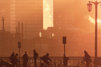
Flood Watch: 'Tricky' Storm Could Dump 3+ Inches of Rain on Hudson Valley, Triggering Flash Floods
Forecasters warn of significant rainfall and flash flooding risk due to a stalled frontal boundary and low pressure system.
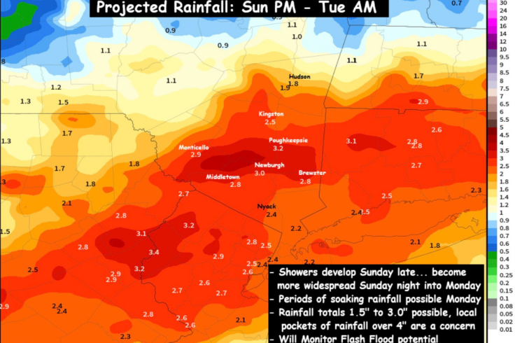
A 'tricky' storm system could dump more than 3 inches of rain on parts of the Hudson Valley between late Sunday and Tuesday, forecasters in the region have warned, raising the risk of flash flooding despite the area's currently dry ground.
The flood watch centres on a stalled frontal boundary and a weak low pressure system that are expected to set up across the Northeast, creating the sort of messy atmospheric mix that can turn an ordinary rainy spell into something far more disruptive.
For context, meteorologists say the pattern has been brewing for days as a front weakened and then stalled over the region, refusing to clear out cleanly to the east. That lingering front is now expected to clash with a developing low pressure system, causing air to converge and rise over the Hudson Valley. When that happens, pockets of intense, slow-moving downpours can form, and the trouble is they seldom set up neatly within county lines.
Hudson Valley Flood Watch Hinges on 'Tricky' Set-Up
Forecasters describe this as a 'significant rainfall event' that could unfold from Monday into Tuesday, with the first scattered showers likely to appear late on Sunday. From there, the atmosphere may start to load the dice in favour of more serious weather: localised torrential downpours, periods of heavy rain persisting for hours in some spots, and rapid runoff into streams and low-lying roads.
The meteorologists behind the alert have been unusually candid about the uncertainty. They note that these kinds of stalled-boundary systems are 'notoriously challenging to forecast,' since tiny shifts in where the front and low pressure overlap can mean the difference between a nuisance drizzle and a flooding deluge a few miles away.
In other words, one town may end up with an inch or so of rain, while the next valley along could take repeated hits from slow-moving cells that drop three inches or more. Trying to pinpoint those hotspots days in advance is, as one forecaster put it, 'nearly impossible.'
That uncertainty does not lessen the concern. If the scenario outlined in model guidance plays out, some areas could experience 'several hours of heavy to torrential downpours over the same areas', raising the likelihood of flash flooding. The ground across much of the Hudson Valley is currently very dry, which sounds reassuring at first but is actually part of the problem.
Very dry soil often struggles to absorb sudden, intense rainfall. Instead of soaking in, the water can sheet straight off fields, pavements and hillsides, speeding into drains, culverts and small rivers. Forecasters warn that 'the runoff could be too much to handle,' leading to localised flooding even in places that have been complaining about drought conditions only days earlier.
How the 'Tricky' Storm Could Unfold Over the Hudson Valley
The expected sequence is deceptively ordinary. Scattered showers begin to develop late Sunday as the moisture builds, followed by more frequent and heavier bursts through Monday. The risk is that the frontal boundary stalls in just the wrong place, allowing bands of rain to repeatedly redevelop and track over the same corridor of the Hudson Valley.
Forecast graphics shared by local weather teams show one potential set-up where a narrow swathe of the region is hit hardest, with several hours of torrential downpours focused on a relatively small area. In that scenario, 'some localised totals over 3 inches can't be ruled out,' the forecasters say.
At this stage, there is no precise map of who gets what. The phrase 'we'll obviously be watching closely and share updates as the event begins to unfold' is doing a lot of work here. It signals that real-time radar, short-term models and ground reports will be more reliable than any early promise that a particular town is safe or doomed.
So, what can residents reasonably do with a forecast that admits it might be very wrong in the details, yet confident about the overall risk? First, treat the flood potential seriously, even if the sky looks unbothered on Sunday afternoon. Flash flooding is often less about drama in the clouds and more about how quickly water moves once it hits the ground.
Secondly, assume the timing is a bit fuzzy. While the headline window is late Sunday through Tuesday, the worst of the weather is currently expected from Monday into Tuesday, when the frontal boundary and low pressure system are most likely to be aligned over the Hudson Valley. Commutes, school runs and any travel that depends on minor roads or underpasses could be affected if those areas end up under the heaviest rain bands.
Local authorities are likely to lean on the same evolving data as residents. While there is no mention yet of formal evacuation guidance or road closures, history suggests emergency managers will be watching the rain gauges and stream levels closely and may move quickly if certain thresholds are hit. Anyone who lives near a small creek that usually behaves itself until it very suddenly does not will know the drill.
For all the science and the models and the jargon about 'dramatic upward motion,' this is one of those events that only truly reveals its character in real time.
The best that forecasters can say now is that a 'tricky' set-up is in place, that it has the potential to unleash more than 3 inches of rain on parts of the Hudson Valley, and that flash flooding is a credible threat rather than a distant, academic possibility.
Whether it turns into a forgettable soaker or the sort of storm people reference years later as 'that mad Monday flood' will depend on exactly where those rain bands choose to stall. And that, frustratingly, is the one detail the atmosphere is not ready to share yet.
© Copyright IBTimes 2025. All rights reserved.
- Recommended For You