Storm Arthur Danger: NWS Warns Just Six Inches Of Water Can Knock You Over
With up to 29 inches of rain recorded in parts of Louisiana and dozens of rescues in Mississippi, forecasters fear 'catastrophic' flooding will continue into the weekend.
Tropical Storm Arthur may have lost its official title over the Gulf of Mexico on Wednesday night, but by early Thursday the weakened system was still driving deadly floods from Texas to Alabama, prompting the US National Weather Service (NWS) to warn that just six inches of fast‑moving water is enough to knock an adult off their feet.
The sprawling remnants of Arthur were pushing ashore across southeastern Louisiana and sweeping east through the Deep South, with forecasters describing an 'unusually high' risk of life‑threatening flash flooding.
Storm Arthur Danger Extends Across The Deep South
The real trouble began to show itself on Thursday as Arthur's heavy rain bands and severe thunderstorms moved into Louisiana before sunrise.
The NWS logged at least one tornado about 20 miles southwest of New Orleans near Boutte, and another storm that may have spun up a tornado near New Orleans International Airport just before 5 a.m. local time. By mid‑morning, the dangerous weather shield was already expanding into Mississippi and Alabama.
NOAA's Weather Prediction Center placed a rare 'high risk' rating on a corridor from eastern Louisiana to the Florida Panhandle, a Level 4 out of 4 threat for excessive rainfall.
'Widespread and potentially life threatening flash flooding is likely as a result of these double‑digit rainfall numbers,' the centre warned.
Arthur's saturated core was forecast to roll over Louisiana, Mississippi, Alabama, Georgia, the Florida Panhandle and the Carolinas through Thursday and Friday, dropping 5 to 10 inches of rain across a broad area with isolated totals potentially reaching an almost absurd 20 inches.
Cities in the crosshairs included New Orleans and Baton Rouge in Louisiana, Jackson, Hattiesburg and Gulfport in Mississippi, and Mobile, Montgomery and Birmingham in Alabama.
Later, the focus shifts towards Atlanta, Macon and Augusta in Georgia and on to Columbia, Charleston and Myrtle Beach in South Carolina, before finally raking Charlotte, Wilmington and Cape Hatteras in North Carolina.
'Catastrophic Rain' And Water Rescues
By late week, the phrase 'Storm Arthur danger' stopped feeling theoretical for people living along the Gulf Coast. The remnants of the storm had already torn through buildings, flooded at least 200 homes in rural Louisiana and triggered a wave of water rescues in Mississippi.
In Avoyelles Parish, Louisiana, meteorologist Donald Jones of the NWS in Lake Charles said more than 2 feet of rain fell in just 48 hours, most of it on Thursday. The highest totals included 29 inches in Cottonport and 22.5 inches in Plaucheville, with nearby Simmesport topping 17 inches.
'Even by this region's standards, that's catastrophic rain,' Jones said.
Mississippi saw its own share of mad scenes. Life‑threatening floods swept through a campground in Perkinston, trapping people in RVs as rescuers reportedly used canoe paddles to smash windows and haul people out.
A rain gauge near the town measured upwards of 12 inches of rain on Thursday, with a similar deluge recorded near Black Creek, about 25 miles to the north.
A spokesperson for the Harrison County Sheriff's Office said that 'roughly 38 people' had been rescued by Thursday night, and that no fatalities or serious injuries had been reported in that area. The National Guard and state wildlife officers were also drafted in to help.
Elsewhere in Mississippi, Governor Tate Reeves said a worker on a county road crew in the south‑west of the state was killed while helping with storm clean‑up operations. He did not disclose the cause of death.
Officials ordered evacuations for around 30 homes below Anchor Lake dam in southern Mississippi amid fears that rising water levels could overwhelm the spillways.
NWS Warns of Dangerous Six Inches Of Water
The most sobering part of the Storm Arthur danger story is that some of the deadliest impacts did not require huge storm surges or hurricane‑force winds. The NWS keeps repeating one simple guideline because people keep underestimating it.
According to the agency, just six inches of fast‑moving floodwater can knock over an adult. A foot of rushing water can carry away most cars. Two feet can take SUVs and trucks. Yet drivers still try to push through flooded roads, and pedestrians still wade into churning currents that look deceptively shallow.
At least two people died in Texas earlier in the week as Arthur's moisture fed into slow‑moving downpours. Local officials said a 53‑year‑old woman was killed near San Antonio when fast‑moving water swept her car off the road, while a 15‑year‑old boy drowned in a flooded retention pond about 40 miles north of Houston.
NWS offices across the region have been blunt in their language. Forecasters in Jackson, Mississippi, described the event as having 'an unusually high ceiling for flooding impacts which could include water rescues being necessary with impassable roadways.'
There is grim precedent here. Since 2013, the majority of tropical storm fatalities have been linked not to winds but to freshwater flooding from heavy rainfall.
Climate Fuel Behind Storm Arthur Danger
Scientists note that the amount of water vapour in the atmosphere has been steadily climbing and set a record in 2024. With the potential for the strongest El Niño on record and new temperature records in 2027, atmospheric moisture is likely to keep rising, loading storms like Arthur with extra fuel.
El Niño events typically change wind patterns in the Atlantic, often making it harder for hurricanes to form in the tropical basin and near the Caribbean.
A patch of unusually cold water in the North Atlantic can also help suppress storm development. But this season, sea temperatures near the US coastline are running above average. That opens the door to short‑lived but extremely wet systems that hug the coast and dump staggering amounts of rain over land before they can organise into classic long‑track hurricanes.
'Arthur is leveraging that extra fuel,' the report notes.
Even as the storm centre moves off the Carolinas and into the Atlantic, forecasters expect more downpours over the Deep South through the weekend, complicating any attempt at clean‑up.
The northern edge of Arthur's rain shield may brush Washington DC, with steadier rain likely in Virginia and Maryland's lower Eastern Shore, where it would fall on ground currently in extreme drought.
Residents in the flood zone do not need another explainer on atmospheric moisture. They are watching canals overtop in Kenner, Louisiana, listening to thunder that 'literally sounded like hell broke open', as Houma resident Coni Dubois put it, and dragging pets, neighbours and strangers' children into boats.
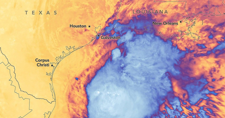
Tropical Storm Arthur is the first named storm of the 2026 Atlantic hurricane season, a compact tropical storm that formed over the warm Gulf waters in mid‑June before tracking towards the US coast.
It never reached hurricane strength but still delivered sustained winds around 40 miles per hour and tropical‑storm‑force gusts as far as 175 miles from its centre, according to the National Hurricane Center.
Earlier this week, Arthur helped unleash 6 to 9 inches of rain and more than 150 reports of flooding from Texas to Alabama, even before its core moisture pushed onshore.
© Copyright IBTimes 2025. All rights reserved.
- Recommended For You