Hawaii Earthquake Update: Did Mauna Loa Erupt and Is There a Tsunami Warning?
A magnitude 6.0 earthquake struck near Mauna Loa on Hawaii's Big Island, causing strong shaking but no tsunami and no signs of fresh volcanic unrest.
A magnitude 6.0 earthquake struck the western flank of Mauna Loa on Hawaii's Big Island on Friday night, but officials said there was no eruption of Mauna Loa and no tsunami warning in effect after the quake.
The US Geological Survey (USGS) reported that the tremor hit at 9:46 p.m. local time, shaking communities across the state yet sparing the islands from the kind of cascading disaster many residents instinctively fear.
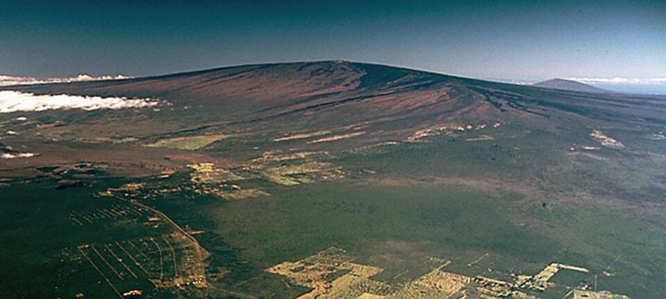
Mauna Loa is the largest active volcano on Earth and last erupted in late 2022, sending lava flows down its slopes and briefly raising global attention on Hawaii's volcanic risks.
Any sizeable earthquake beneath or near the mountain tends to trigger immediate speculation about whether magma is on the move or a tsunami might follow. Authorities moved quickly on Friday night to shut down those rumours and focus on what was actually happening on the ground.
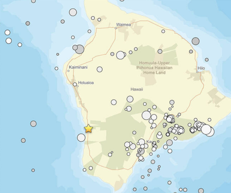
The quake was centred about 7 miles south of Honaunau-Napoopoo and 22 miles south-southeast of Kailua-Kona, at a depth of roughly 14 miles, according to USGS data. It was originally logged as magnitude 5.9 but upgraded to 6.0 after further analysis, a modest revision that can nonetheless change how engineers and emergency planners rate the event.
The Hawaii Police Department said large rocks and debris tumbled onto Napoopoo Road as the ground shook, prompting officers to close both lanes between the 10-mile marker and Middle Keei Road.
The closure allowed crews to work through the night clearing the route, a familiar dance in a region where steep slopes and narrow roads leave little margin when rocks start moving.
The Pacific Tsunami Warning Center confirmed that the earthquake did not generate a tsunami. Some coastal areas still experienced strong shaking, but the feared wall of water never materialised. That distinction matters in Hawaii, where tsunami sirens and evacuation routes are imprinted on local memory.
USGS scientists were blunt in their assessment of any link between the quake and Mauna Loa's volcanic systems. 'The earthquake had no apparent impact on either Mauna Loa or Kilauea volcanoes,' they said in a statement, adding that the event was not a sign of imminent eruption.
Instead, seismologists traced the cause to the slow, grinding physics of the Pacific plate under the islands. 'The depth, location, and recorded seismic waves of the earthquake suggest that it was caused by stress due to bending of the oceanic plate from the weight of the Hawaiian island chain; the earthquake was not directly related to volcanic processes,' the statement continued.
In other words, this was the Earth adjusting to the immense bulk of the islands themselves, rather than magma forcing its way upwards. Even so, the shaking was anything but abstract for those on the west side of the island. USGS described it as 'strong to very strong' in some communities, with the potential for light to moderate damage to infrastructure.
Cracks, fallen items and minor structural issues are all being checked, though there were no immediate reports of serious injuries. The agency urged residents to report any damage to the County of Hawaii Civil Defense Agency, effectively turning the public into an extended sensor network.
Within an hour of the quake, more than 2,600 people had submitted 'Did you feel it?' responses online, a self-reporting tool that has become a key part of USGS rapid assessments. Most reports came from the Big Island, but entries also flowed in from Kauai, Oahu, Maui and smaller communities including Kapaa, Lahaina, Mililani, Kaunakakai and Lanai City.
No Eruption, Widespread Shaking
The Mauna Loa earthquake update from USGS and local agencies sketched a picture of a strong but contained event. A magnitude 6 tremor sits in the 'strong' category on USGS scales, with 'light' property damage considered possible. In practical terms that can mean plaster cracks, toppled shelves or minor structural strains rather than collapsed buildings.
Several aftershocks rattled the same area in the minutes and hours that followed. The largest noted in initial reports was a magnitude 3.2 quake at about 9:52 p.m., also on the western flank of Mauna Loa. Scientists said more aftershocks are expected in the coming days, though they are 'unlikely to be large enough to be felt or cause damage.'
That reassurance does not entirely silence nerves in a region used to living with volcanic giants. When a strong quake hits this close to Mauna Loa, people reach instinctively for comparisons with past crises. Officials, for their part, appear determined to keep the lines clear between measured risk and worst-case speculation.
Tsunami Warning
The speed of the Hawaii earthquake update on tsunami risk was as important as the message itself. Within a short time, the Pacific Tsunami Warning Center confirmed that no tsunami had been triggered by the Mauna Loa earthquake, allowing coastal communities to stand down from the most alarming scenario.
This episode also underscored how routine earthquakes and extreme volcanic events can be easily conflated in public perception. The scientific agencies took pains to say that Friday's tremor was driven by tectonic bending under the weight of the islands, not by pressurised magma.
As residents clear debris and check for cracks, the island returns to its uneasy normal, living on the flank of the world's largest active volcano, where the ground occasionally reminds everyone who is really in charge.
© Copyright IBTimes 2025. All rights reserved.
- Recommended For You