Space Technology Reveals Deadly Venezuela Earthquakes Shifted Earth's Crust By 30 Centimetres
ESA radar satellites uncovered a stunning 30-centimetre shift in Venezuela's crust after twin earthquakes, exposing dramatic ground movement that no one on the surface could see.

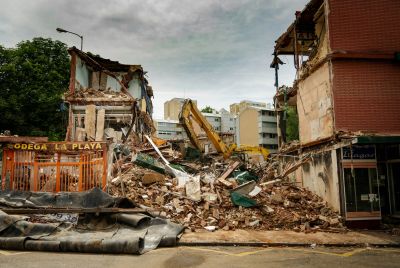
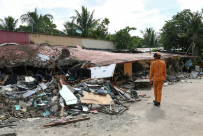
The deadly Venezuela earthquakes did more than topple buildings and leave communities reeling. They also changed the landscape itself, and scientists only realised the full extent of that transformation after looking at the disaster from space.
Using advanced space technology, researchers discovered that part of northern Venezuela's crust shifted by around 30 centimetres, nearly a foot, after two powerful earthquakes struck the region. It is the kind of movement no one could have spotted from the ground, yet satellites orbiting hundreds of kilometres above Earth detected it with remarkable precision.
The finding offers a striking reminder that while earthquakes unfold in seconds, they can permanently reshape the planet beneath our feet.
New satellite imagery reveals how much terrain has shifted in the wake of the twin quakes. https://t.co/VLFuWEyJyQ
— WIRED (@WIRED) July 1, 2026
Satellites Saw What People Could Not
The discovery came from the European Space Agency, whose Sentinel-1 satellites are designed to do far more than capture pictures of Earth.
Unlike conventional imaging satellites, Sentinel-1 uses radar to send signals towards the planet's surface and measure how long they take to return. By comparing radar observations taken on different dates, scientists can identify tiny shifts in the landscape, even when those changes are invisible to the naked eye.
To investigate the Venezuela earthquakes, researchers compared a radar scan collected on 18 June, when the ground was still undisturbed, with another captured on 25 June, the day after the devastating magnitude 7.2 and 7.5 earthquakes.
That simple before-and-after comparison revealed something extraordinary.
Security camera footage from the port city of La Guaira shows the moment twin magnitude 7.2 and 7.5 earthquakes ripped through Venezuela on June 24.
— NewsForce (@Newsforce) July 1, 2026
2,000 people killed, more than 10,500 injured… many more still missing. pic.twitter.com/o2GjAMV6dv
A Colourful Map Exposed A Hidden Shift
The radar data was transformed into what scientists call an interferogram, a specialised map that translates ground movement into colourful bands.
At first glance, the image resembles rows of bright stripes stretching across northern Venezuela. In reality, every complete sequence of colours represents another increment of change between the satellite and the Earth's surface.
The more colour cycles visible, the greater the overall displacement.
Those bands converged around the earthquake's epicentre, where the European Space Agency estimated the Earth's crust shifted by roughly 30 centimetres.
Thirty centimetres may not sound dramatic until you consider what actually moved. It was not a crack in a road or a damaged building, but part of the Earth's crust itself, displaced within moments by the immense forces released during the earthquakes.
The San Sebastián Fault Was At The Centre
The deformation closely followed the San Sebastián Fault, one of northern Venezuela's most significant tectonic fault systems.
That alignment gives scientists valuable clues about where stress was released beneath the surface and how the fault responded during the earthquakes.
However, the radar data cannot reveal exactly how the land moved. An earthquake can force the ground upwards, downwards, sideways, or in several directions at once. The interferogram measures the overall change in distance, not the direction of the movement itself.
Answering that question will require additional satellite observations and detailed field surveys.
Rescue Efforts Come Before Scientific Surveys
Those on-the-ground investigations are unlikely to begin immediately.
With buildings damaged, infrastructure disrupted, and communities facing a growing humanitarian crisis, emergency response remains the priority. Scientists will have to wait before they can compare the satellite measurements with field observations.
Even so, the space-based data is already proving invaluable.
NASA activated its Disaster Response Coordination System, joining an international effort to analyse satellite information, identify high-risk areas and support emergency teams working across the affected region.
It is a reminder that modern satellite earthquake imagery is no longer just a scientific tool. It has become an essential part of disaster response, helping authorities understand conditions on the ground even when access is limited.
Why This Discovery Matters
Measuring ground displacement after an earthquake is about far more than producing dramatic images.
Every radar observation helps scientists understand how fault systems behave, how seismic energy is released, and how landscapes change after major earthquakes. That knowledge improves hazard assessments and strengthens future earthquake research.
The Venezuela earthquakes also demonstrated just how powerful modern space technology has become. Within days, satellites detected subtle changes across the landscape that people standing on the ground could never have seen.
As rescue and recovery continue, the colourful radar bands have become more than a scientific curiosity. They are a lasting record of the moment the Earth's crust shifted beneath northern Venezuela, a transformation witnessed not by those living through the disaster, but by satellites silently watching from orbit.
© Copyright IBTimes 2025. All rights reserved.
- Recommended For You