Powerful Earthquake Triggers Tsunami Fears in the Philippines: Is the Country Still at Risk?
Authorities confirmed that while initial tsunami alerts were issued, the situation remained under close observation.
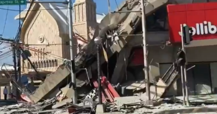
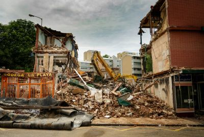
A powerful earthquake off the southern Philippines has triggered widespread tsunami fears, forcing evacuations and prompting urgent monitoring across coastal regions as officials assess whether further waves could follow.
The quake, which struck in a highly active seismic zone, led to immediate warnings across parts of the Philippines and neighbouring regions. Emergency agencies moved quickly to assess coastal risks, as aftershocks continued to shake already-damaged areas.
Authorities confirmed that while initial tsunami alerts were issued, the situation remained under close observation as scientists analysed whether the undersea movement had displaced enough water to generate destructive waves.
Why Earthquakes Can Trigger Tsunamis
Tsunamis are typically caused when a sudden shift in the Earth's crust displaces large volumes of water, usually during undersea earthquakes. According to the United States Geological Survey (USGS), not all earthquakes generate tsunamis—only those that involve significant vertical movement of the seafloor are capable of producing large waves.
When tectonic plates suddenly shift, the ocean above is forced upward or downward, creating waves that can travel across entire ocean basins at high speed. These waves may be barely noticeable in deep water but grow dramatically in height as they approach shallow coastal zones.
Experts note that the magnitude of an earthquake alone does not determine tsunami risk; rather, the depth, location, and type of fault movement are critical factors.
Lessons From the 1976 Moro Gulf Disaster
The Philippines has experienced devastating tsunami events in its history, most notably the 1976 Moro Gulf earthquake, which triggered a massive tsunami that killed thousands of people along the southern coastline.
That disaster occurred when a powerful undersea quake struck near the Cotabato Trench, generating waves that hit coastal communities with little warning. Entire villages were destroyed, and the event remains one of the deadliest tsunamis in the region's recorded history.
Seismologists often reference this event when assessing tsunami risk in the Philippines, as it highlights how quickly coastal populations can be affected when undersea fault zones rupture.
Why the Philippines Is So Vulnerable
The Philippines sits along the Pacific 'Ring of Fire', one of the most seismically active regions in the world, where multiple tectonic plates collide and slide beneath one another.
According to UNESCO's Intergovernmental Oceanographic Commission, earthquakes become tsunamis when seafloor displacement pushes water upward, creating waves that radiate outward from the epicentre.
Because the Philippines is surrounded by deep ocean trenches and active fault lines, it remains one of the most tsunami-prone countries globally. This geological setting means even moderate undersea earthquakes can trigger warnings depending on their depth and movement.
Authorities Monitor Aftershocks and Coastal Risk
Following the recent quake, officials have continued to monitor aftershocks, which are common after major seismic events and can persist for days or even weeks. These smaller tremors can complicate rescue operations and raise fears of further structural instability in already damaged areas.
Emergency response teams have been deployed to coastal provinces, where tsunami risk assessments are prioritised due to the population density and proximity to active fault zones.
While no major tsunami wave was confirmed immediately after the quake, authorities stressed that vigilance remains essential until full seismic data is analysed.
Could the Philippines Still Be at Risk?
Seismologists caution that tsunami risk does not always disappear immediately after the initial quake. Secondary underwater landslides or delayed fault movement can still generate waves, particularly in complex tectonic zones like those surrounding the Philippines.
However, experts also emphasise that modern monitoring systems significantly improve early warning capabilities compared to historical events such as the 1976 Moro Gulf disaster.
For now, the situation remains under active observation, with scientists continuing to evaluate whether the quake's underwater displacement was sufficient to generate further tsunami activity.
© Copyright IBTimes 2025. All rights reserved.
- Recommended For You